Navigating the Future: A Student Pilot's Guide to PBN for the EASA IR
Welcome, future Instrument-Rated pilots! As you get ready for your EASA IR, you'll quickly find that Performance-Based Navigation (PBN) is a cornerstone of modern aviation. It might seem like a complex topic at first, but understanding PBN is key to flying safely and efficiently in today's airspace. This guide will help you grasp the essentials of PBN, making your IR training smoother and your future flights more confident.
What Exactly is Performance-Based Navigation (PBN)?
Think of PBN as a smart way of flying. Instead of just relying on ground-based navigation aids, PBN focuses on what your aircraft's navigation system can actually do – its performance. The International Civil Aviation Organization (ICAO) defines PBN as "Area navigation based on performance requirements for aircraft operating along an ATS route, on an instrument approach procedure or in a designated airspace". Essentially, it's about ensuring your aircraft can meet specific accuracy, integrity, continuity, and functionality standards for a particular flight path or airspace.
One of the cool things about PBN is that it aims to be technology-independent, even though Global Navigation Satellite Systems (GNSS) are a major enabler. As long as your aircraft meets the performance criteria, the specific equipment used isn't the primary concern.
Key Goals of PBN in Air Traffic Management (ATM):
- Enhanced Safety: Precise flight paths reduce risks like Controlled Flight Into Terrain (CFIT) and help keep aircraft safely separated.
- Increased Airspace Capacity and Efficiency: PBN allows for more flexible routes, like parallel tracks and optimized SIDs/STARs, which means better airspace use and potentially shorter flights.
- Greener Flying: More direct routes and optimized descents can lead to less fuel burn, fewer emissions, and reduced noise.
- Predictability: Standard performance makes flight paths more predictable, helping air traffic controllers manage traffic.
- Better Access: PBN can open up airports in tricky terrain or weather where older procedures were limited.
PBN vs. Old-School Navigation: What's the Big Deal?
Traditionally, pilots navigated using signals from ground-based aids like VORs and NDBs. This often meant flying "dog-leg" routes from one beacon to the next. PBN, on the other hand, lets aircraft fly more direct paths because it's based on the aircraft's overall navigation capability, often using GNSS or a multi-sensor Flight Management System (FMS).
Advantages of PBN:
- Flexible & Efficient Routes: More direct flying saves time, fuel, and money.
- More Airspace Capacity: Closer routes and more efficient SIDs and STARs are possible.
- Improved Safety: Precise approaches, including those with vertical guidance, boost safety. Required integrity and continuity further enhance safety.
- Less Ground Gear Needed: Reliance on GNSS can reduce the need for many ground beacons.
- Eco-Friendly: Shorter routes mean lower emissions and noise.
- Globally Standardized: PBN provides a worldwide framework for navigation.
The Building Blocks of PBN
PBN isn't just one thing; it's a concept built on four key components:
- Airspace Concept: This is the big picture plan for how a specific airspace will be used, including traffic types and flow. It sets out what's needed for communication, navigation, and surveillance.
- Navigation Specification: Stemming from the Airspace Concept, this details the performance needed from aircraft navigating in that airspace. It specifies accuracy, integrity, continuity, and required functionalities. These are categorized as RNAV (Area Navigation) or RNP (Required Navigation Performance).
- Navaid Infrastructure: This refers to the ground and space-based navigation aids (like GNSS, VORs, DMEs) that must be available to support the Navigation Specification.
- Navigation Application: This is where it all comes together – the actual use of a Navigation Specification and the navaid infrastructure for specific routes or procedures like SIDs, STARs, and approaches. It includes flight crew procedures, training, and aircraft eligibility.
Think of it this way: the Airspace Concept defines the need, the Navigation Specification sets the performance bar, the Navaid Infrastructure provides the tools, and the Navigation Application is how you use it all in flight.
RNAV and RNP: What's the Difference?
You'll hear "RNAV" and "RNP" a lot. Both are types of area navigation, but there's a crucial difference.
- RNAV (Area Navigation): Allows aircraft to fly any desired path within navaid coverage or within the limits of self-contained systems. An RNAV specification defines performance requirements but *doesn't* require on-board performance monitoring and alerting for that specific RNAV standard.
- RNP (Required Navigation Performance): This is a PBN navigation specification that *does* require on-board performance monitoring and alerting. This system will warn you if your navigation system can't guarantee it's meeting the required performance.
The key takeaway: RNP systems actively monitor themselves and tell you if something's not right for the RNP value of the procedure, whereas RNAV systems don't have this specific mandated monitoring and alerting tied directly to the RNAV specification itself.
Decoding PBN Designations (e.g., RNAV 1, RNP APCH)
Those letters and numbers in PBN specifications (like RNAV X or RNP Y) tell you about the lateral navigation accuracy in nautical miles (Total System Error - TSE). This accuracy should be met for at least 95% of the flight time.
Here are some common ones:
- RNAV 10 (often called RNP 10): Accuracy of 10 NM, typically for oceanic and remote en-route operations.
- RNAV 5: Accuracy of 5 NM, used for en-route continental and arrival phases.
- RNAV 1 / RNP 1: Accuracy of 1 NM, used in arrivals, departures (SIDs/STARs), and initial/intermediate approaches. RNP 1 is especially useful where air traffic surveillance is limited.
- RNP APCH: Used for approaches (like LNAV, LNAV/VNAV, LPV), with accuracy often scaling down to 0.3 NM on the final segment.
- RNP AR APCH (Authorization Required): For challenging approaches needing special aircraft capabilities, crew training, and state approval. Can have very high accuracy, like RNP 0.1.
Cool PBN Features You'll Use
PBN brings some clever functionalities to the cockpit:
- RF (Radius to Fix) Legs: These define precise curved paths between fixes, essential for navigating complex terminal procedures efficiently. Flying these requires specific aircraft approval.
- Baro-VNAV (Barometric Vertical Navigation): This system uses barometric altitude to provide vertical guidance, enabling 3D approaches like LNAV/VNAV. Be aware of temperature limitations if your system isn't temperature-compensated, as this can affect the accuracy of the vertical path.
- Parallel Offsets: Allows you to fly a track parallel to your main route, useful for traffic separation or weather avoidance.
- Holding Patterns: PBN systems can accurately fly database-defined holding patterns, including entries.
GNSS: The Power Behind PBN
Global Navigation Satellite Systems (GNSS) are the primary enablers for most PBN operations.
- How it Works: GNSS receivers use signals from multiple satellites (at least four for a 3D position and time) to calculate position. The standard coordinate system is WGS-84.
- GNSS Errors: Things like ionospheric/tropospheric delays, multipath signals, satellite clock/orbit errors, and the geometry of satellites (Dilution of Precision - DOP) can affect accuracy.
- Augmentation Systems (Making GNSS Better):
- ABAS (Aircraft-Based Augmentation System): Uses on-board systems like RAIM (Receiver Autonomous Integrity Monitoring) to check GNSS integrity. FDE (Fault Detection and Exclusion) is an enhanced RAIM that can identify and exclude a faulty satellite.
- SBAS (Satellite-Based Augmentation System): Systems like EGNOS in Europe or WAAS in the US use ground stations and geostationary satellites to send corrections, significantly improving GNSS accuracy, integrity, continuity, and availability. SBAS enables LPV approaches, which are similar to ILS precision.
- GBAS (Ground-Based Augmentation System): A ground station at an airport provides highly accurate corrections via VHF data broadcast, supporting precision approaches (CAT I, II, III).
Understanding Total System Error (TSE)
For PBN, the Total System Error (TSE) is the overall difference between where your aircraft actually is and where it *should* be on the defined path. The RNP value (e.g., RNP 1) means the TSE must be within that value (e.g., 1 NM) for 95% of the flight time.
TSE has three main parts:
- Path Definition Error (PDE): Difference between the intended path and the path in your navigation database.
- Flight Technical Error (FTE): How accurately you (or the autopilot) fly the aircraft along the displayed path.
- Navigation System Error (NSE): Difference between your aircraft's true position and the position calculated by your navigation system. RNP systems monitor NSE.
PBN in Action: Departures, Arrivals, and Approaches
SIDs and STARs:
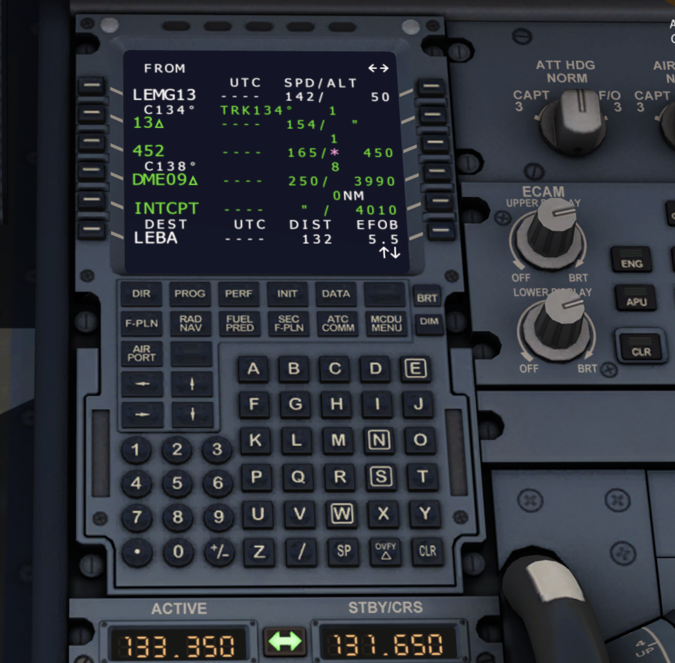
- Naming & Charting: PBN SIDs and STARs have specific naming conventions and are clearly depicted on charts. Your navigation database will use an ARINC 424 identifier, which should be cross-checked.
- Flying Them: Requires retrieving the procedure from a current database and meticulously cross-checking it against published charts. Strict adherence to tracks, speeds, and altitude constraints is mandatory unless changed by ATC.
RNP Approaches (RNP APCH):
- Structure: Common designs include "T-bar" or "Y-bar" configurations leading to an Initial Approach Fix (IAF), Intermediate Fix (IF), Final Approach Fix (FAF), and Missed Approach Point (MAPt). Terminal Arrival Altitudes (TAAs) provide minimum altitudes in sectors around IAFs, helping with descent planning.
- Types of Minima:
- LNAV (Lateral Navigation): A 2D approach with only lateral guidance to an MDA(H).
- LNAV/VNAV (Lateral/Vertical Navigation): A 3D approach with lateral and approved vertical guidance (often Baro-VNAV or SBAS-derived) to a DA(H).
- LPV (Localizer Performance with Vertical Guidance): A 3D approach, highly reliant on SBAS, offering ILS-like precision to a DA(H), sometimes as low as 200 feet.
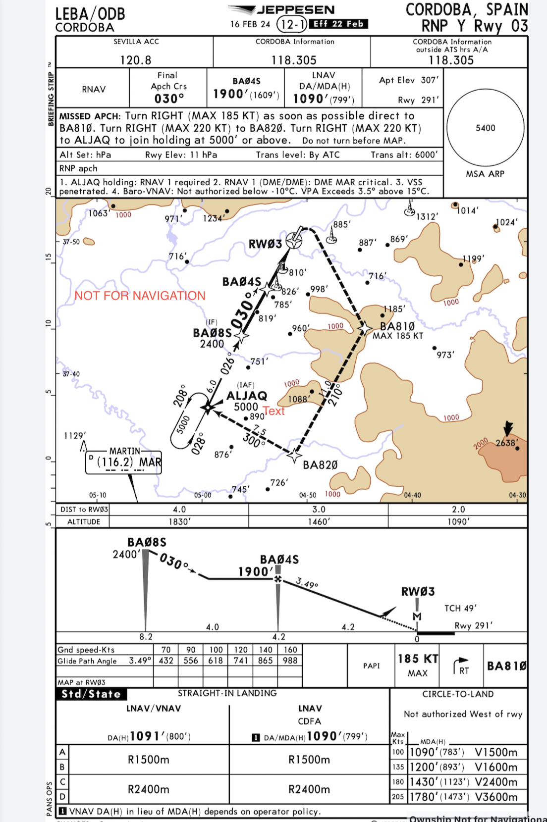
- Flying an RNP APCH: Involves careful pre-flight planning (RAIM/SBAS checks, NOTAMs), system setup, approach selection and meticulous verification against charts, flying the lateral and vertical profiles accurately, and being ready for the missed approach.
- GNSS Alerts/Downgrades: If you get a GNSS integrity alert (like "LOI" or "INTEG") during an RNP approach, especially on final, you must execute an immediate missed approach and inform ATC. If SBAS is lost and your approach mode downgrades (e.g., LPV to LNAV), you'll need to use the minima for the new, less precise service, or go around if it happens below 1000 ft AAL on final.
Watch Out! Common Human Factor Challenges in PBN
PBN systems are fantastic, but they bring their own set of human factors challenges:
- Automation Management: Over-reliance or complacency can set in. Understanding what the automation is doing (avoiding the "What's It Doing Now?" or WIDN phenomenon) is critical, especially with things like waypoint sequencing at the MAPt. Data entry errors are also a common pitfall.
- Situational Awareness: Don't just follow the magenta line! Keep your broader awareness of geography, terrain, weather, and traffic.
- Workload: Terminal phases can be busy. Reprogramming the FMS/GNSS due to ATC changes can significantly increase workload.
- Training & Proficiency: A solid understanding of PBN concepts, system limitations, and procedures is a must.
Tips to Mitigate Errors:
- Thorough Training: Get good initial and recurrent PBN training.
- Stick to SOPs: Use and follow Standard Operating Procedures diligently.
- Meticulous Planning: Review charts, verify database currency, and cross-check everything.
- Master Your Automation: Know your system's modes and logic inside out.
- Stay Aware: Monitor your progress and the bigger picture continuously.
- Use Checklists: Follow aircraft-specific checklists for PBN operations.
Getting Your PBN Wings: Pilot Requirements
For your EASA IR, PBN privileges are integrated into your training and testing. You'll need to show:
- Theoretical Knowledge: Understanding PBN concepts, terms, and procedures.
- Practical Skill: Ability to fly PBN procedures, including at least one RNP APCH during your skill test.
Filing Your Flight Plan: PBN Codes
It's crucial to tell ATC about your aircraft's PBN capabilities. This is done through specific codes in your ICAO flight plan:
- Item 10a (Equipment):
- G: GNSS
- R: PBN approved (this tells ATC to look at Item 18 for PBN details)
- B: LPV (APV with SBAS)
- Item 18 (Other Information) - PBN/ string: You list specific PBN navigation specifications here (up to 8 codes). Common codes include:
- RNAV: A1 (RNAV 10), B1/B2 (RNAV 5), C1/C2 (RNAV 2), D1/D2 (RNAV 1)
- RNP: L1 (RNP 4), O1/O2 (Basic RNP 1), S1 (RNP APCH for LNAV/LNAV/VNAV), S2 (RNP APCH with Baro-VNAV)
Filing these correctly is essential so ATC can give you the right routes and procedures.
Final Approach to PBN Mastery
PBN is a vital part of modern instrument flying. By understanding its principles, components, and operational aspects, you'll be well-prepared for your EASA IR and a future of safe and efficient flying. Keep studying, ask questions, and practice those procedures. You've got this!
Disclaimer: This blog post is for informational purposes only and should not be used as a substitute for official EASA regulations, flight training manuals, or instruction from a certified flight instructor. Always refer to the latest official documentation and consult with your flight instructor for any flight-related decisions.